Global Irrigated Area Mapping
Introduction
Knowing where the irrigated areas are is of important implications in decision making processes for food security, poverty alleviation, water resources management, and environmental conservations. This site presents results of IWMI's first attempt to map global irrigated and rainfed croplands for the nominal year of 2000 using satellite images. The products include 10 km irrigated and rainfed cropland and a LULC map for the globe, 500 meter irrigated area map for South Asia, and 30 meter irrigated area maps for Syr Darya River Basin in Central Asia and Krishna River Basin in India. The maps contain various levels of information including irrigation water sources (surface, groundwater), cropping intensity (single, double, continuous) and dominant crop types. Detailed statistics and communication materials including posters and publications are also provided.

Interactive GIAM
- Global Level
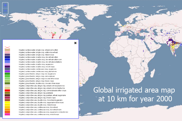
- Global irrigated area map at 10 km for year 2000 Download
- Global rainfed area map at 10 km for year 2000 Download
- Global map of land use/land cover areas at 10 km for year 2000 Download
- Regional Level
- South Asia irrigated area map at 500 meter resolution for year 2000 Download
- Basin Level
- Krishna River Basin (Central Asia) irrigated area map at 30 meter resolution for year 2000 Download

Graphs
- Areal extent of glaciers and seasonal snow in 1961-1990
- Water storage properties of glaciers and seasonal snow in 1961-1990
- Contribution of glaciers and snow to MAF in 1961-1990
- Contribution of glaciers and snow to MAF: changes between 1961-1990 and 2000-2010
- Composition of glacier runoff in 1961-1990 and 2000-2010 (GRr - renewable component; GRnr - nonrenewable component)
Key Publication
- Thenkabail, P.S., Biradar, C.M., Turral, H., Noojipady, P., Li, Y.J., Vithanage, J., Dheeravath, V., Velpuri, M., Cai, X. L. and Dutta, R. 2006. An Irrigated Area Map of the World (1999) derived from Remote Sensing. IWMI Research Report 105.
- Thenkabail, P.S., Biradar, C.M., Turral, H., Noojipady, P., Li, Y.J., Dheeravath, V., Cai, X. L., Velpuri, M., Vithanage, J., Schull M., and Dutta, R. 2009. A Global Irrigated Area Map (GIAM) using time-series satellite sensor, secondary, Google Earth, and Groundtruth data. International Journal of Remote Sensing. 30(14): 3679-3733.
- Biradar, C.M., Thenkabail, P.S., Noojipady, P., Li, Y., Dheeravath, V., Turral, H., Velpuri,M., Gumma, M.K., Reddy, G.P.O., Cai, X.L., Xiao, X., Schull, M.A., Alankara, A.D., Gunasinghe, S. and Mohideen, S. 2009. A global map of rainfed cropland areas (GMRCA) at the end of last millennium using remote sensing. International Journal of Applied Earth Observation and Geoinformation. 11 (2009) 114�129.
- Thenkabail, P.S., Biradar C.M., Noojipady, P., Cai, X.L., Dheeravath, V., Li, Y.J., Velpuri, M., Gumma, M., Pandey., S. 2007. Sub-pixel area calculation methods for estimating irrigated areas. 7: 2519-2538.
- NM Velpuri, PS Thenkabail, MK Gumma, C Biradar, V Dheeravath, P Noojipady, L Yuanjie, 2009. Influence of resolution in irrigated area mapping and area estimation. Photogramm. Eng. Remote Sensing, 75, 1383-1396.
- V Dheeravath, PS Thenkabail, G Chandrakantha, P Noojipady, GPO Reddy, CM Biradar, MK Gumma, M Velpuri, 2010. Irrigated areas of India derived using MODIS 500 m time series for the years 2001�2003. ISPRS Journal of Photogrammetry and Remote Sensing, 65 (1), 42-59.
Iternationl Water Management Institute
Headquarters : 127,Sunil Mawatha, Pelawatte, Battramulla, Sri lanka. Telephone +94-11 2880000 | Fax: +94-11 2786854 |
Email: [email protected]
This page was last updated on Friday, Aprial 25, 2014